Woodman of the World Cemetery

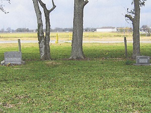
Main Name: Rosenberg City Cemetery | FB-C002

Alternate Names:

  • W.O.W. Cemetery
  • Woodman of the World Cemetery

Access: There is public access to the cemetery.

Location: Ave D, Rosenberg

NAD83 Coordinates: 29 33.819 N, 95 48.822 W

Map Coordinates: 29.563649, -95.813702

Status and Other Information: The cemetery status is active and it has a Historical Marker. The cemetery is not affiliated with any organizations and the ethnicity is mixed. The size of the cemetery is 9.45 acres. The number of known burials is 3,041 and the date of the earliest burial is 09/12/1910.


View Rosenberg City Cemetery - FB-C002 in a larger map


William J. Stafford Family Cemetery

Main Name: Stafford Family Cemetery | FB-C119

Alternate Names:   

  • Adams Cemetery
  • Stafford Cemetery
  • William J. Stafford Cemetery
  • William J. Stafford Family Cemetery

Access: Access to the cemetery is via PRIVATE property. Permission from the land owner MUST be obtained prior to visiting the cemetery.

Location: Avenue E, Stafford

NAD83 Coordinates: 29 36.361 N, 95 35.163 W

Map Coordinates: 29.606017, -95.586050

Status and Other Information: The cemetery status is inactive. The cemetery is not affiliated with any organizations and the ethnicity is primarily Anglo. The size of the cemetery is 0.7 acre. The number of known burials is 5 and the date of the earliest burial is unknown.

View Stafford Family Cemetery | FB-C119 in a larger map

William J. Stafford Cemetery

Main Name: Stafford Family Cemetery | FB-C119

Alternate Names:   

  • Adams Cemetery
  • Stafford Cemetery
  • William J. Stafford Cemetery
  • William J. Stafford Family Cemetery

Access: Access to the cemetery is via PRIVATE property. Permission from the land owner MUST be obtained prior to visiting the cemetery.

Location: Avenue E, Stafford

NAD83 Coordinates: 29 36.361 N, 95 35.163 W

Map Coordinates: 29.606017, -95.586050

Status and Other Information: The cemetery status is inactive. The cemetery is not affiliated with any organizations and the ethnicity is primarily Anglo. The size of the cemetery is 0.7 acre. The number of known burials is 5 and the date of the earliest burial is unknown.

View Stafford Family Cemetery | FB-C119 in a larger map

Wilderness Branch Baptist Church Cemetery | FB-C136

Photo Taken Date: 2014

Wilderness Branch Baptist Church Cemetery | FB-C136

Main Name: Wilderness Branch Baptist Church Cemetery | FB-C136

Alternate Names:

  • None 

Access: There is public access to the cemetery

Location: 6207 FM 359, Rosenberg

NAD83 Coordinates: : 29 37.794 N, 95 48.446 W

Map Coordinates: : 29.62990, -95.80743

Status and Other Information: The cemetery status is inactive. The cemetery is affiliated with a religious organization and the ethnicity is primarily Anglo. The size of the cemetery is 0.89 acres. The number of known burials is 6 and the date of the earliest burial is 12/12/1863.

White Lake Cemetery

Main Name: Hodge’s Bend Cemetery | FB-C024

Alternate Names:

  • White Lake Cemetery 

Access: Public

Location: Old Richmond Road, Sugar Land

NAD83 Coordinates: 29 38.446 N, 95 39.741 W

Map Coordinates: 29.640767, -95.662350

Status and Other Information: The cemetery status is inactive and it has a Historical Marker  The cemetery is not affiliated with any organizations and the ethnicity is primarily Anglo.  The size of the cemetery is 1.00 acre.  The number of known burials is 72 and the date of the earliest burial is 1831.


View Hodge’s Bend Cemetery - FB-C024 in a larger map


White Cemetery | FB-C167

Photo Taken Date: 2012

old-JOnes

Main Name: White Cemetery | FB-C167

Alternate Names:

  • Old Jones Cemetery, Jones Cemetery

Access: Cemetery access is via PRIVATE property. Permission from the land owner MUST be obtained prior to visiting the cemetery.

Location: Near Bellaire Blvd, Rosenberg

NAD83 Coordinates: 29 40.819 N, 95 47.481 W

Map Coordinates: 29.68032, -95.79135

Status and Other Information:

The cemetery status is inactive. The cemetery is not affiliated with any organizations and the ethnicity is primarily Anglo. The size of the cemetery is 0.10 acre. The number of known burials is 12 and the date of the earliest burial is 05/05/1903.

Wheat Family Cemetery | FB-C081

Photo Taken Date: 2013

Wheat Family Cemetery | FB-C081

Main Name: Wheat Family Cemetery | FB-C081

Alternate Names:

  • Wheat Cemetery

Access: Cemetery access is via PRIVATE property. Permission from the land owner MUST be obtained prior to visiting the cemetery.

Location: Near FM-361, Fairchilds

NAD83 Coordinates: 29 24.949 N, 95 43.212 W

Map Coordinates: 29.41583, -95.72021

Status and Other Information: The cemetery status is inactive. The cemetery is not affiliated with any organizations and the ethnicity is mixed. The size of the cemetery is 0.01 acres. The number of known burials is 7 and the date of the earliest burial is 03/16/1857.


View Wheat Family Cemetery - FB-C081 in a larger map

Wheat Cemetery

Photo Taken Date: 2013

Wheat Family Cemetery | FB-C081

Main Name: Wheat Family Cemetery | FB-C081

Alternate Names:

  • Wheat Cemetery

Access: Cemetery access is via PRIVATE property. Permission from the land owner MUST be obtained prior to visiting the cemetery.

Location: Near FM-361, Fairchilds

NAD83 Coordinates: 29 24.949 N, 95 43.212 W

Map Coordinates: 29.41583, -95.72021

Status and Other Information: The cemetery status is inactive. The cemetery is not affiliated with any organizations and the ethnicity is mixed. The size of the cemetery is 0.01 acres. The number of known burials is 7 and the date of the earliest burial is 03/16/1857.


View Wheat Family Cemetery - FB-C081 in a larger map

West Gethsemane Cemetery | FB-C028

Main Name: West Gethsemane Cemetery | FB-C028

Alternate Names:

  • Gethsemane Cemetery
  • Holy Rosary Catholic Cemetery

Access: Public

Location: Hwy 36, Rosenberg

NAD83 Coordinates: 29 32.211 N, 95 48.476 W

Map Coordinates: 29.536850, -95.807933

Status and Other Information: The cemetery status is active.  The cemetery is not affiliated with any organizations and the ethnicity is mixed.  The size of the cemetery is 2.64 acres.  The number of known burials is 809 and the date of the earliest burial is 08/31/1906.


View West Gethsemane Cemetery - FB-C028 in a larger map


Wenceslaus Cemetery

Main Name: St. Wenceslaus Catholic Cemetery | FB-C007

Alternate Names:

  • Beasley Catholic Cemetery
  • Wenceslaus Cemetery

Access: Public

Location: Loop 540, Beasley

NAD83 Coordinates: 29 30.021 N, 95 54.778 W

Map Coordinates: 29.500350, -95.912967

Status and Other Information: The cemetery status is active. The cemetery is affiliated with a religious organization and the ethnicity is primarily Anglo. The size of the cemetery is 2.23 acres. The number of known burials is 165 and the date of the earliest burial is 08/17/1919.


View St. Wenceslaus Catholic Cemetery - FB-C007 in a larger map


Subscribe to Historical Commission